|
The
(unofficial) version 1.2 update is now avaliable and allows
you additional FS2000 functionality. Please go to this
page for download information.
|
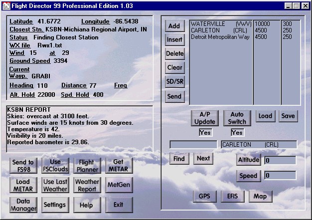
Flight Director is an integrated Flight Planning,
GPS,EFIS, Weather, and ATC companion for Microsoft Flight Simulator.
Flight Director is the comprehensive add-on to help you
navigate and simulate the world around you. Integrated with the included
Real Weather allows you to fly through actual current weather conditions!
The flight planning features are as powerful and flexible
and supports both custom and automatic flight plans. Flight Director
can manage entire flights from departure to the arrival pattern, including
airspeed, heading, and altitude. One "click" transmits flight plans
or NAVAIDs to the aircraft autopilot and navigation systems. Voice
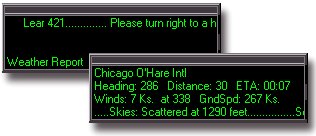
Synthesized ATC (Air Traffic Control) provides vectored instructions.
This entirely new system takes ATC to new levels of fun and simplicity.
Comprehensive Navigation Tools
Flight Director's editable 25,000-entry database overflows
with waypoints, NAVAIDs (Navigational Aids), and airports. Its abilities
to add, edit, and remove entries and import custom navigational databases
helps ensure ongoing accuracy and worldwide coverage.
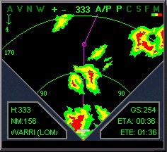
A full-featured EFIS (Electronic Flight Information System)
connects to the autopilot and navigation systems. A GPS (Global Positioning
System) displays your location, heading, distances, and en route time estimates.
A Moving Map provides 360° views of your location.
Incredible Real or Custom Weather Conditions
An advanced weather engine can uses real-world Internet
METAR data to reflect actual current worldwide weather conditions.
Color-coded Cloud and Weather Radar display surrounding cloud densities
and conditions ranging from light drizzle to the heaviest thunderstorms.
Automatic reports reflect weather changes. On-demand reports can
display any reporting station's conditions.
FSClouds & Textures Pro Integration
If you have FSClouds, a direct link can be made with Flight
Director allowing the FSClouds cloud textures to be automatically used
during your flights.
Flight Director 99 Specification List
-
You can download the latest METAR data from the Internet
and have the weather in Flight Simulator automatically updated during your
flight.
-
The program works with the FSClouds 3.0 program bringing
you many advanced cloudscapes.
-
There is a full-featured EFIS with a direct connection to
the Flight Simulator navigation features and autopilot. All your surrounding
Navaids can be displayed.
-
A GPS is available with Navaid, heading, distance to, and
approx. time enroute all displayed. Current weather reports also automatically
appear when you reach a new weather area.
-
A moving map gives you a 360-degree view around your location
and includes many of the same features as the EFIS.
-
Weather Radar is available in the EFIS and Map showing precipitation
from light drizzle all the way up to heavy thunderstorms.
-
You can use a special cloud radar giving you color-coded
cloud density of your surrounding area.
-
A flight planner that you can use to create flight plans.
It can also auto-generate basic flight plans for you.
-
Included is the FS Career Kit with fun and easy ATC (Air
Traffic Control). Using almost any flight plan that you create, you
can be vectored to your destination by Air Traffic Control. These are not
typical "Adventures" but an entire new system using voice synthesized speech.
You are also graded on your piloting
-
skills after each flight and this is applied to career totals
and salary.
-
Weather Builder (MetGen). You can design and attach custom
weather to any point in yoour flight plan and it will b automatically updated
as you fly. So if you do not have access to METAR data, or you just want
to fly with your own custom created weather, you can do it using this feature.
-
Your flight plan can be automatically sent to the Flight
Simulator autopilot. This includes speed and altitude. So with proper planning
you can let Flight Director practically fly your whole flight from airport
to airport
-
Taking you right into the arrival pattern.
-
Flight Director contains a database that contains over 23,000
waypoints, navigational beacons, and airports. You can also edit the database
to add or remove waypoints or even import other complete databases.
-
Get weather reports from all over the world using the new
weather-reporting interface. This includes a simple point and click search
engine.
-
A Visual Map Planner allows you to make complete flightplans
using a point and click visual interface. You can see the route of your
flight as you build it.
-
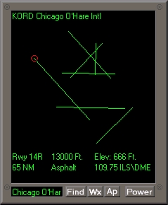
There are new Airport utilities. Graphically view detailed
airport and runway information including length, type, and altitude.
-
Get weather reports for each airport with suggested runway
to use based on winds at that airport. This information is based on the
real world weather you download from the Internet.
-
Database optimization. There is now a feature that will allow
you to customize what areas of the Flight Director database will be loaded
in memory. This will improve FD99 performance.
-
Current weather is always displayed on the main screen. The
new EFIS instruments also have automatic weather reports.
-
Auto radio frequency. You can now specify whether you want
the navigation radios to automatically send the radio frequency to the
FS98 radios whenever you reach a new waypoint.
-
Winds can be automatically factored into the direction to
your next waypoint allowing you to stay accurately on a given flight path
or jetway.
-
New customizable descent features. You can now specify how
many minutes prior to reaching a targeted waypoint that you will arrive
at the specified descent altitude.
-
ATC Check Lists. You can now configure custom checklists
of up to 150 list items that you can play before, during, and after your
flight.
-
Print Flight Plans. Flight plans can be printed with a lot
of enroute information. If you have the current weather loaded you will
be given departure and arrival weather in the printout.
-
There is a new GPS gauge. This gauge can be used in any of
your panels and is compatible with full screen 3Dfx (Voodoo 1 and 2) mode.
-
Unique flight tracking mode. In the new Gauge GPS, there
are special tracking needles that can help guide you to any airport, VOR,
NDB, or waypoint intersection.
-
Special temperature and wind customizations can be made from
the Settings screen.
-
SIDS and STARS can be easily created and archived using our
new built in SIDS and STARS system.
-
The new Approach Builder will build approaches into your
desired runway.
-
Special ILS style approaches can be activated allowing Flight
Director 99 to place you right on the runway
-
threshold. If your airport does not have an ILS, let
Flight Director 99 simulate one.
-
Aircraft Profiles are implemented to allow for more accurate
flight planning.
-
Improved flight planing is implemented with a small graphical
display showing your route.
-
Works with ProFlight 98 by AETI. You can be vectored by your
adventure to the correct runway based on the real world winds at
that airport.
-
Use Flight Director 99 with Then Next Generation by AETI
and Up Front Simulations. Receive weather reports directly through your
FMC.
-
Import the complete ProFlight 98/Up front database into Flight
Director allowing both databases to match.
-
Convert flight plans for use in the ProFlight 98/Up front
FMC's.
|
|